‘Severe and Devastating’: Hurricane Michael Causes $3 Billion to $5 Billion in Damage

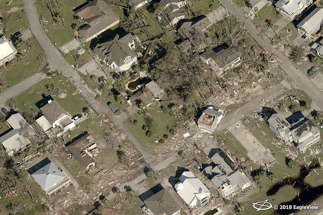
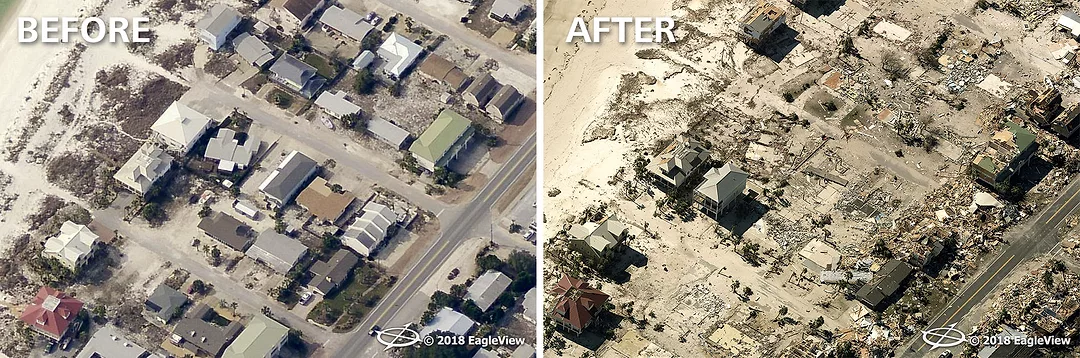
Eagle View Technologies took aerial images of damage inflicted by Hurricane Michael in October 2018. Photo courtesy of Eagle View Technologies.
Research firms and aerial image providers are among the first to offer extensive insight into the damage caused by Hurricane Michael - and how much rebuilding needs to be done.
CoreLogic reports that the storm caused an estimated $3 billion to $5 billion in damage. Based on early projections and modeling, the company previously said damage could be in the neighborhood of $13.4 billion.
As the research firm reported, flooding was not the primary culprit in damage done in the area, unlike Hurricane Florence and others. Instead, the widespread damage was caused by high, sustained wind speeds.
Florida no doubt saw the worst damage. Nearly 5,200 residential and commercial structures in Panama City were walloped by Category 4 hurricane conditions About 36,000 structures in the same area dealt with Category 3 conditions, about 37,000 were hit with Category 2, and still another roughly 28,000 had to cope with Category 1 conditions. Another 67,000 structures also were damaged in Tallahassee and the surrounding region.
CoreLogic reports about 3,000 structures in Alabama were hit with Category 1 conditions, while about 14,000 structures in Georgia dealt with either Category 1 or Category 2 conditions.
Following the storm, companies like Eagle View Technologies and Nearmap began documenting damage from the sky, essentially allowing for conditions to be recorded so work on repairs could begin as soon as possible.
As it did with Hurricane Florence, Eagle View used satellite, drone and fixed wing aircraft to document the damage from above, once granted access into the airspace by the Federal Aviation Administration. Resulting offerings include the company’s proprietary ultra-high-solution Reveal imagery.
With post-event imagery, insurance carriers can close claims rapidly despite high post-storm volumes, and local government agencies can quickly provide aid to those impacted — and contractors can get to work sooner.
Eagle View was in the air within 18 hours of the storm making landfall.
Between work done before and after the storm, the company had more than 400 million images that clearly show just how powerful the storm was as it tore through the region.
“Our high-resolution aerial imagery along with our machine learning capabilities truly offer customers a complete understanding of the damage seen,” stated EagleView CTO Ajai Sehgal. “Our teams are working day-in and day-out to ensure that our customers are getting the answers they’re looking for from our imagery and data analytics.”
By applying advanced machine learning technology to the pre- and post-imagery, EagleView can highlight and categorize any potential property damage in each image by stratifying properties based on probability thresholds. This added technology allows insurance carriers to rapidly analyze the imagery and classify damage efficiently, resulting in an overall faster closing of claims.
“Machine learning is changing the way our customers respond to disasters like Hurricane Michael,” said EagleView CEO Rishi Daga. “In the end, we want to make sure communities can begin to rebuild, and with this advanced technology, they’ll be able to do so quicker than ever before.”
Other companies also took to the air immediately following the storm.
Nearmap, which specializes in high-resolution aerial maps, also documented the damage to aid “cleanup and recovery efforts in many industries, including public safety, utility companies, and insurance agencies and numerous types of contractors.”
“At first look, the damage from Hurricane Michael appears to be severe and devastating,” said Rob Newman, CEO and managing director of Nearmap. “Our thoughts are with those who are dealing with the aftermath and loss from the hurricane. Getting aerial imagery to critical agencies as soon as possible will assist in the recovery efforts.”
Looking for a reprint of this article?
From high-res PDFs to custom plaques, order your copy today!

.webp?height=740&t=1781278983&width=auto "KEE(2).png")


