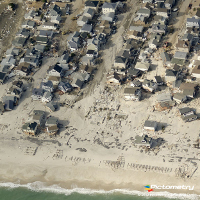
NEW YORK, N.Y. — As the effects of Superstorm Sandy continue to unfold, government agencies, counties, utilities and major insurance carriers are turning to a oneof- a-kind technology to help them better assess the extent of the devastation: high-resolution, oblique aerial imagery shot from a fleet of custom-built, low-flying airplanes.
Aircraft from Rochester, N.Y.-based Pictometry International Corp. were rapidly deployed to many of the hardest hit areas, making low-altitude flights over the region. The company has already collected more than 160,000 data-rich, Sandy-specific images – 1.2 terabytes – that allow for before-and-after comparisons of property damage directly from desktops, tablets and other mobile computing devices.
 NEW YORK, N.Y. — As the effects of Superstorm Sandy continue to unfold, government agencies, counties, utilities and major insurance carriers are turning to a oneof- a-kind technology to help them better assess the extent of the devastation: high-resolution, oblique aerial imagery shot from a fleet of custom-built, low-flying airplanes.